South Downs Way
223 kr
223 kr
To., 19 juni - ti., 24 juni
Sikker betaling
14 dagers åpent kjøp
Selges og leveres av
AdlibrisProduktbeskrivelse
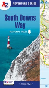
The A-Z Adventure Series uses Ordnance Survey mapping and is the perfect companion for walkers, off-road cyclists, and anyone wishing to explore the great outdoors.
Starting in Winchester and finishing in Eastbourne, the scenic South Downs Way is a 100 mile (160 km) National Trail route lying within the South Downs National Park.
This National Trail Map features detailed Ordnance Survey mapping at a scale of 1:25 000, providing complete coverage of the South Downs Way. It also includes a route planner showing distances between places and the amenities available to make it easy to plan your adventure. Additional features include:
- Campsites (seasonal opening)
- Information Centres
- Hotels/B&Bs
- Youth Hostels
- Public Houses
- Shops
- Restaurants
- Cafes (seasonal opening)
- Petrol Stations
Other books available in the A-Z Adventure series include: Peak District (Dark Peak), Cotswold Way, Peddars Way and Norfolk Coast Path, Pembrokeshire Coast Path, South West Coast Path and The North Coast 500.
Artikkel nr.
90fc9c95-ff52-5b24-85f6-dbb4c2e7f056
South Downs Way
223 kr
223 kr
To., 19 juni - ti., 24 juni
Sikker betaling
14 dagers åpent kjøp
Selges og leveres av
AdlibrisLignende toppselgere

POP MART Labubu The Monsters – Exciting Macaron Blind Box 17 cm Vinylfigur | Samleleke | Designerfigur | Originalt produkt
249 kr
")
1 stk POP MART Labubu 3.0 Big into Energy Blind Box-figur – The Monsters Vinyl Plysch Hänge 17 cm (tilfeldig farge, enkel pakke)
249 kr

POP MART Labubu The Monsters Big into Energy 17 cm
249 kr
")
1 stk POP MART Labubu 2.0 The Monsters Macaron Blind Box Plysjfigur (tilfeldig farge, 17 cm, generasjon 2, 1-pakning)
249 kr

POP MART Labubu The Monsters – Big into Energy Series Blind Box 17 cm Vinylfigur | Samlefigur | Designerleke | Originalt produkt
249 kr

Labubu The Monsters Macaron Blind Box fra POP MART
259 kr
")
1 kpl POP MART Labubu The Monsters Spennende Macaron Plysjfigur leketøy Blind Box (tilfeldig farge, 17 cm, 1 pakke)
239 kr

Øreputer for Bose QuietComfort - QC35/QC25/QC15/AE2 Hodetelefoner Svart
99 kr

INF TYPE-C Dual SD/TF-kortleser for rask dataoverføring 0
99 kr
Tidligere laveste pris:
107 kr

Pop Mart Labubu Stitch Sleep Snack Series
349 kr
Anbefalinger til dig

3-Pak - Fidget Spinners med Sugekopp for Barn
119 kr
Tidligere laveste pris:
139 kr

G9 LED-lyspærer – Varmhvit – 10stk
119 kr

10x Premium hjørnebeskyttelse og kantbeskyttelse for barn
119 kr
Tidligere laveste pris:
146 kr

Silikontape / Plaster for Arr – Behandling av arr
99 kr

RCA til HDMI Converter 1080p - Adapter
139 kr

Universallader for Garmin klokker Svart
89 kr

INF Ultralett turstav med 5 seksjoner 1 par Rød
379 kr
Tidligere laveste pris:
546 kr
")
French Avenue Liquid Brun Eau De Parfum 100 ml (man)
483 kr
Tidligere laveste pris:
513 kr

Luftrenseenhet - Renser / Saniterer luften - 20,000 mg/h
599 kr

6x60ml = 360ml - Kirkland Extra Strength 5% Men Hair Regrowth 60ml Hair Loss
1 390 kr