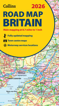
2026 Collins Road Map of Britain
203 kr
203 kr
Tidligere laveste pris:
204 kr
On., 4 juni - ti., 10 juni
Sikker betaling
14 dagers åpent kjøp
Selges og leveres av
Adlibris
Produktbeskrivelse
Full-colour, double-sided road map of Great Britain at a scale of 8.7 miles to 1 inch. Northern England, Scotland and the Isle of Man are on one side with Southern England and Wales on the other.
With its easily identifiable counties and unitary authorities,this map is ideal for business users but it is also perfect for tourists for route planning.
Main features:
- Fully updated
- Counties and local council areas shown in colour
- Clear, detailed road network
- Town and city names, rivers and canals are clearly shown
- 16 city/town centre street plans
- Index to place names
- Mileage chart
- Car ferry routes
- Key in English, French and German
Artikkel nr.
204d3f34-f155-536e-9bfa-b04ac33a4233
2026 Collins Road Map of Britain
203 kr
203 kr
Tidligere laveste pris:
204 kr
On., 4 juni - ti., 10 juni
Sikker betaling
14 dagers åpent kjøp
Selges og leveres av
Adlibris
Lignende toppselgere

POP MART Labubu The Monsters Macaron 17 cm
219 kr

POP MART Labubu The Monsters Big into Energy 17 cm
239 kr

Øreputer for Bose QuietComfort - QC35/QC25/QC15/AE2 Hodetelefoner Svart
99 kr

POP MART Labubu The Monsters Have a Seat 17 cm
229 kr
 - Spillekonsoll - 1TB SSD NVme - Wi-Fi/LAN - Hvid")
Sony | Playstation® 5 Slim (Digital-versjon) - Spillekonsoll - 1TB SSD NVme - Wi-Fi/LAN - Hvid
5 741 kr
Tidligere laveste pris:
5 774 kr

Luftrenseenhet - Renser / Saniterer luften - 20,000 mg/h
599 kr

Playstation 5 DualSense Controller Midnight Black
799 kr

Silikontape / Plaster for Arr – Behandling av arr
99 kr
Tidligere laveste pris:
129 kr

Anti-snork Bånd / Magnetiske Plaster - Stopper snorking
149 kr

INF TYPE-C Dual SD/TF-kortleser for rask dataoverføring 0
99 kr
Tidligere laveste pris:
107 kr
Anbefalinger til dig

Plenlufter - Piggsko for å lufte plenen
269 kr

Hundetrimmer / Potetrimmer - Trimmer for Poter
199 kr

6x60ml = 360ml - Kirkland Extra Strength 5% Men Hair Regrowth 60ml Hair Loss
1 390 kr

4-Pak - Tesla Senterkopper - Bil Svart/silver
129 kr
")
Lattafa - Kharmah - Eau De Parfum 100 ml (unisex)
458 kr

Geberit AquaClean Avkalkingsmiddel 4 stk
460 kr
Tidligere laveste pris:
461 kr

3-Pak - Fidget Spinners med Sugekopp for Barn
119 kr
Tidligere laveste pris:
139 kr

3x Kirkland Extra Strength 5% Men Hair Regrowth 60ml Hair Loss
749 kr

Vektbelagt Rockering 1,2kg
190 kr
Tidligere laveste pris:
249 kr

10x Premium hjørnebeskyttelse og kantbeskyttelse for barn
119 kr
Tidligere laveste pris:
146 kr