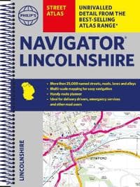
Philip's Navigator Street Atlas Lincolnshire
295 kr
295 kr
Ti., 20 mai - ma., 26 mai
Sikker betaling
14 dagers åpent kjøp
Selges og leveres av
Adlibris
Produktbeskrivelse
The only county Street Atlas with all the named streets of Lincolnshire and perfect back-up for emergency services, delivery drivers, visitors and locals.
With more than 24,000 named streets, roads, lanes and alleys, this is the essential map book for residents and visitors - especially if you're in a hurry.
Includes all the streets in BOSTON, GRANTHAM, GRIMSBY, LINCOLN, PETERBOROUGH, SCUNTHORPE, Alford, Barton-upon-Humber, Bourne, Brigg, Chapel St Leonards, Cleethorpes, Coningsby, Gainsborough, Holbeach, Horncastle, Immingham, Long Sutton, Louth, Mablethorpe, Market Deeping, Market Rasen, Skegness, Sleaford, Spalding, Spilsby, Stamford.
- Street mapping clearly shows car parks, stations, schools, hospitals and many places of interest, even those off the beaten path
- A practical route-planning section showing all A and B roads
- Super-clear mapping
- Easy-to-use index
- Scales: 1¾ inches to 1 mile (1:36,000) and 3½ inches to 1 mile (1:18,000). Major towns: 7 inches to 1 mile (1:9,000).
Other information on the maps includes postcode boundaries, car parks, railway and bus stations, post offices, schools, colleges, hospitals, police and fire stations, places of worship, leisure centres, footpaths and bridleways, camping and caravan sites, golf courses, and many other places of interest.
Artikkel nr.
3c4cbfef-c852-4b8f-b322-8dc9fa038460
Philip's Navigator Street Atlas Lincolnshire
295 kr
295 kr
Ti., 20 mai - ma., 26 mai
Sikker betaling
14 dagers åpent kjøp
Selges og leveres av
Adlibris
Lignende toppselgere

Øreputer for Bose QuietComfort - QC35/QC25/QC15/AE2 Hodetelefoner Svart
99 kr
 - Spillekonsoll - 1TB SSD NVme - Wi-Fi/LAN - Hvid")
Sony | Playstation® 5 Slim (Digital-versjon) - Spillekonsoll - 1TB SSD NVme - Wi-Fi/LAN - Hvid
5 884 kr

Pelsfjerner for Klær & Nuppefjerner - Fjern Lo & Hår
99 kr

4-Pak - Tesla Senterkopper - Bil Svart/silver
129 kr

Luftrenseenhet - Renser / Saniterer luften - 20,000 mg/h
599 kr

Anti-snork Bånd / Magnetiske Plaster - Stopper snorking
149 kr

Universalfjernkontroll BN59-01312A for Samsung Smart 4K LED Svart No Voice
139 kr
Tidligere laveste pris:
145 kr

Sangean MMR88 sveivradio med lommelykt, solcelle, USB, gul/svart
1 169 kr

Rengøringsklud, Vileda PVAmicro, 38x35cm, blå
294 kr
Tidligere laveste pris:
314 kr

INF TYPE-C Dual SD/TF-kortleser for rask dataoverføring 0
99 kr
Tidligere laveste pris:
107 kr
Anbefalinger til dig

Lader for iPhone - Hurtiglader - Adapter + Kabel 20W USB-C
129 kr

Plenlufter - Piggsko for å lufte plenen
269 kr

Geberit AquaClean Avkalkingsmiddel 4 stk
461 kr

Microfiberklud PVAmicro 38x35cm grøn,5 stk/pk
278 kr
Tidligere laveste pris:
294 kr

Universallader for Garmin klokker Svart
89 kr

2-pakning iPhone 11 altskjermbeskytter i herdet glass
79 kr

Hundetrimmer / Potetrimmer - Trimmer for Poter
199 kr

SERO Apple Macbook magsafe 2 lader, 60W - for Macbook Pro 13" m. Retina skjerm Hvit
349 kr

INF Stylus Pen kompatibel med iPad 2018-2023-serien HvitiPad
199 kr
Tidligere laveste pris:
285 kr

Lofjerner klær - Pelsfjerner - Hårfjerner
87 kr